
The Port That Was Born Old: When Buenos Aires Chose Prestige Over Function
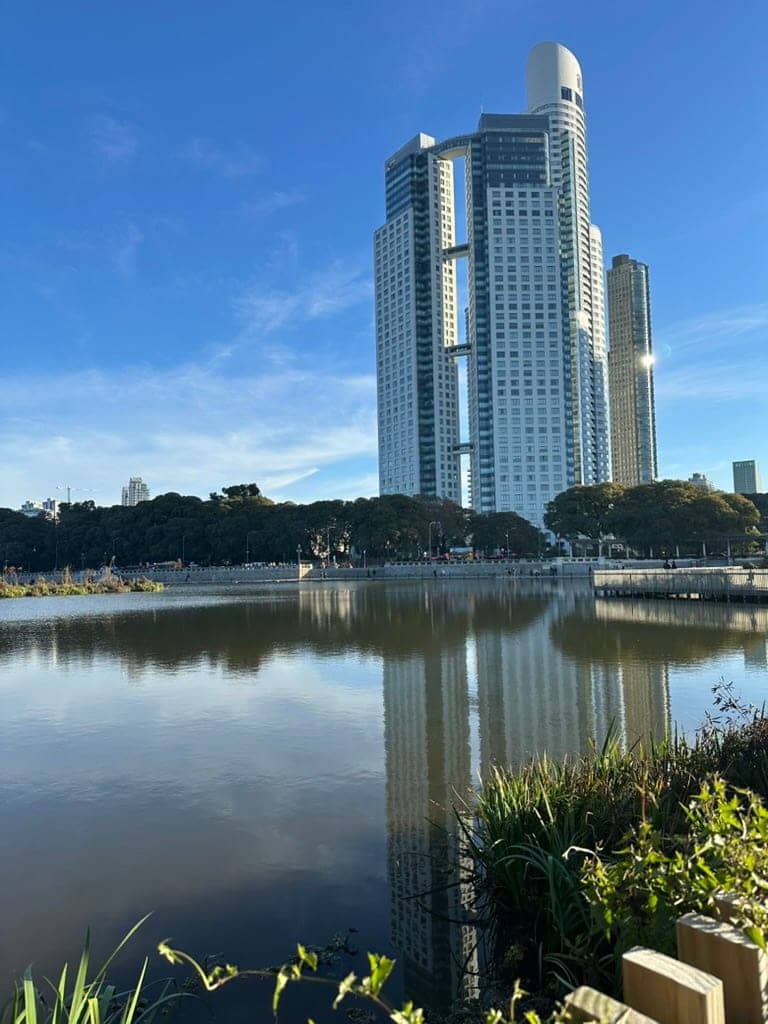
A story of urban decisions, necessary failures, and the courage to reinvent
Did you know Buenos Aires chose to build a port that wouldn’t work just to look like Europe? This is the story of Puerto Madero: when prestige beat pragmatism… and how that “failure” became Latin America’s boldest urban transformation.
In 1882, two projects disputed not just the port of Buenos Aires, but the idea the city had of itself. Luis Huergo—engineer, pragmatic—proposed straight piers following the river’s geography: functional, economical, designed for a port-city growing from work. Eduardo Madero—nephew of Vice President Francisco Madero, well-connected—imagined closed docks Liverpool-style: symmetrical, ornamental, worthy of a capital that always looked to Europe before understanding itself.
The battle between creole pragmatism and imported prestige was won by Madero. Between 1887 and 1898, English architects John Hawkshaw and Harrington Hayter designed from London a port that Thomas Walker & Co. built with red brick docks that looked like industrial cathedrals transplanted from England. Armstrong Whitworth cranes presided over a beautiful but dysfunctional port: it was scenography before infrastructure.
By 1911 they were already building Puerto Nuevo following—irony of fate—Huergo’s ideas. In 1925, the last ships abandoned Madero’s docks. The port born to impress remained an urban relic: over 60 years of abandonment, with monumental warehouses taken over by entire colonies of rats, in the heart of a city that preferred not to look toward the river.
The Archaeology of Abandonment
My grandmother saw it from her ANMAT office: that landscape of abandonment Buenos Aires had naturalized. Brick warehouses bitten by humidity, metal structures rusting in the open, weeds growing between railway tracks. It was the exact reverse of the dreamed port: the place where the city stored its most visible failure.
For over half a century, Puerto Madero was the porteño urban unconscious. There lay the consequences of choosing appearance over function, prestige over pragmatism. The 1882 decision had become ruins, and the ruins had become normality.
But cities, like people, sometimes need to hit bottom to reinvent themselves.
The Laboratory of Reinvention
In 1991, when the Antiguo Puerto Madero Corporation—an unprecedented mixed management model in Argentina—decided it was time to transform that urban edge, it wasn’t just about recovering buildings. It was redefining what city we wanted to be. Again, geography as politics; urbanism as self-portrait.
My father moved near Puerto Madero in the late ‘90s, when cranes still drew the skyline and every walk was archaeology of the future. We went to watch the El Faro towers grow, to walk the Puente de la Mujer as if we were the first to step on it, to witness how the old Molinos silos became lofts with the Armstrong Whitworth cranes still present as silent witnesses of this place’s two eras: industrial and residential.

The parks with straight lines and millimetric grass were our laboratory of modernity: a Buenos Aires without broken sidewalks or improvised corners. But also something more: planned green spaces where there was only abandonment, pedestrian walks connecting the city with the river, cultural infrastructure democratizing access to contemporary art.
Because Puerto Madero isn’t just corporate towers and restaurants over the dock—though that’s the most sold postcard. It’s also the Fortabat Museum with first-class Argentine art, the Ecological Reserve that self-regenerated over rubble, the running paths where anyone can train for free, the Nereidas Fountain that migrated from Plaza de Mayo to find its definitive place facing the river, the historic frigate Sarmiento telling Argentine naval history.

Beyond the Tourist Postcard
Later I moved nearby and Puerto Madero became my morning running track, my green refuge in a city breathing concrete, my direct connection to the river without traffic light mediation. There I understood this neighborhood has multiple layers of use, not all visible in tourist guides.
At 7 AM, while waiters dressed as gauchos still sleep, Puerto Madero belongs to runners, dog walkers, retirees doing tai chi facing the river. At 8, it fills with office workers walking toward their mirrored corporate buildings. At 6 PM, it’s territory for families seeking free space for kids to ride bikes. On weekends, it transforms into a rest destination: picnics, bike rides, and mate.
Is it gentrification? Yes, also. But it’s more complex than that.
The Politics of Urban Transformation
Here’s the tension that defines Puerto Madero and, really, defines every successful urban transformation: can a space be simultaneously exclusive and inclusive? Can state planning coexist with private investment without one canceling the other?
For many porteños, Puerto Madero remains empty ostentation, a non-place that doesn’t belong to them, a real estate experiment disguised as a neighborhood. And they’re partially right: it’s expensive to live there, many restaurants target tourism, the aesthetics sometimes seem forced.
But it’s also true that where there was wasteland now there are 28 hectares of public green spaces within the Puerto Madero project. That Costanera Sur, which went from elegant beach resort in the ’20s to marginalized zone in the ‘70s, today is part of the largest green space complex in downtown Buenos Aires along with the 350-hectare Ecological Reserve. That Argentine art has an exhibition space (the Fortabat Museum) that didn’t exist before. That thousands of people can access the river in a city that historically turned its back on water.

One of the new walkways in the Ecological Reserve.
Puerto Madero’s true lesson isn’t that urban transformation is good or bad per se. It’s that cities, like living organisms, need to evolve or die. And that sometimes, paradoxically, the most resounding failure can become the most valuable opportunity.
Buenos Aires chose wrong in 1882. It built an English port on River Plate geography, prioritized image over function, bet on imported prestige over local innovation. The result was predictable: a port that didn’t work, obsolete before turning 40.
But that error became, a century later, the raw material for one of Latin America’s boldest urban transformations. Abandoned Victorian warehouses became lofts and cultural centers. Dysfunctional docks transformed into water mirrors multiplying the sky. Rusty rails became green paths.
The Geography of the Present
I insist Puerto Madero is to be lived: to breathe air coming from water, to see art between historic docks, to understand that sometimes a city needs to invent spaces where none existed. It’s not nostalgia or pure speculation: it’s geography of the present, a piece of Buenos Aires that dared not resemble any other.
Is it perfect? No. Is it inclusive? Not completely. Did it solve all Buenos Aires’ urban problems? Of course not.
But it did achieve something that seemed impossible: returning the river to a city that had forgotten it was a port. And that, in a metropolis of 15 million inhabitants, is no small thing.
Next time you walk through Puerto Madero—whether to run, see an exhibition, or yes, even eat at one of those restaurants overlooking the dock—remember you’re stepping on the materialization of a question all cities ask themselves: who are we and who do we want to be?
Buenos Aires took 109 years to answer it. But when it did, it built not just a new neighborhood, but a new way of thinking about itself.
And tell me: Do you have your own Puerto Madero experience? Or some place in your city that completely changed and generates mixed feelings? I love reading these stories in the comments.
If this story resonated with you, sha
Want to receive my newsletter? Subscribe to "El Baùl Cultural" on my Substack!
A weekly space for reflection where I share my experiences, expressed through my passions: reading, travel, film, art, politics, and technology.
In northern Argentina, August is celebrated by feeding the earth. In Italy, by closing the office.
In five days I received two messages.
The first came from the road that links Salta and Jujuy. A friend riding shotgun, telling me she was taking the day off to celebrate the first of August, as one should. I confess I had to google it.
The second arrived in writing, from a design studio in Alba, Piemonte. They were happy: the holidays are coming. Ferragosto is near.
In northern Argentina, as in other Andean regions, this is the dry season, so on the first of August a hole is dug in some corner of the garden, the balcony, the mountain, and the family offers the earth what it likes best: empanadas, wine, coca leaves, a fizzy drink. The earth is fed. Thanks are given, prosperity and fertility are asked for, and the empanadas and wine pass on to the guests. The siku, played in pairs because each musician holds half the notes, the chacareras, rock or cumbia sound in the background, and it all turns into a party.
In Italy, around these dates, the opposite happens. The 15th of August has been celebrated since Roman times. The tradition comes from the Feriae Augusti, the rest after the labours of the field decreed by the emperor, which later absorbed a Christian tradition, the Assumption of the Virgin. Over there it’s hot and everything is closed. If you’re in the city, you’re probably a foreigner. It’s not the earth that eats and drinks, but the Italians. Saying Buon Ferragosto is a way of closing the office, greeting the family and taking the train to leave the concrete behind.
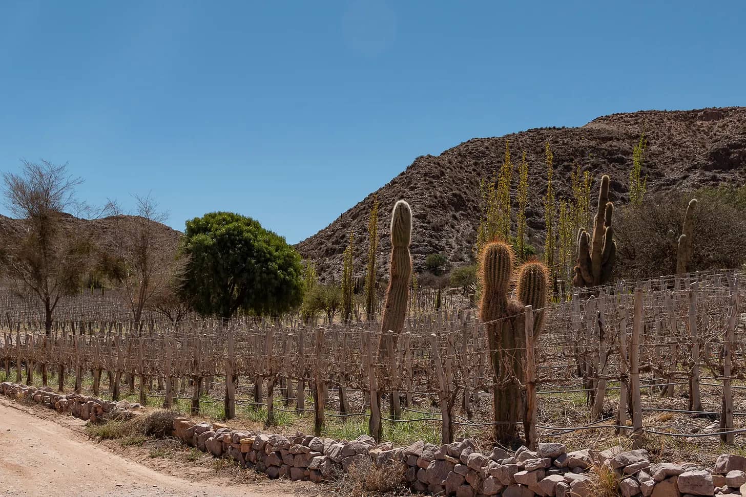
Something else is done in Argentina at this time of year, in the Litoral mostly, though it has spread a little to the rest of the country: drinking caña con ruda. Last Sunday was the first Vino de Viaje gathering, where we drank not caña but wine. One of the wines was from Jujuy, from the Quebrada de Humahuaca, a desert around the Río Grande. It’s hard to imagine vineyards there, among hills of seven and fourteen colours and cardón cacti several metres tall. But thirst suits the vine: less water, smaller bunches, each grape more concentrated. And the high-altitude radiation thickens its skin.
In Piemonte, between the Ligurian Sea and the Alps, the August heat has an expiry date: by October you can’t see the vineyard next door. That’s where Nebbiolo is harvested, a grape named after the fog and pale all the same: little colour, plenty of tannin.
The desert where you can see everything gives an opaque wine. The fog where you can see nothing gives a transparent one.
Besides the wine, I told them how to travel to each bottle: where the Dupont estate sits in Maimará, what you cross on the road, where to stop. And we talked about the pasacana, the cardón’s fruit, with those white hairs. I didn’t tell the legend: a cacique’s daughter who fled with a forbidden love, and Pachamama, who sheltered them by turning them into what they are now. She stayed there, embracing him, under the green poncho.
My friend has already toasted the earth and is driving back along that road. In Alba they’re closing the studio. The cardones are still there, standing in the desert.
Originally published in The Detour on 10 August 2026.
A cash-only ferry, an accidental detour, and a full-scale replica 8,000 kilometres away.
When I told my mother I was going to the Alps, she said not to miss Hallstatt. It was the place she had loved most on her trip fifteen years earlier. She warned me it wasn’t easy to get to, that she had gone with a tour. Stubborn as I am, I decided not to.
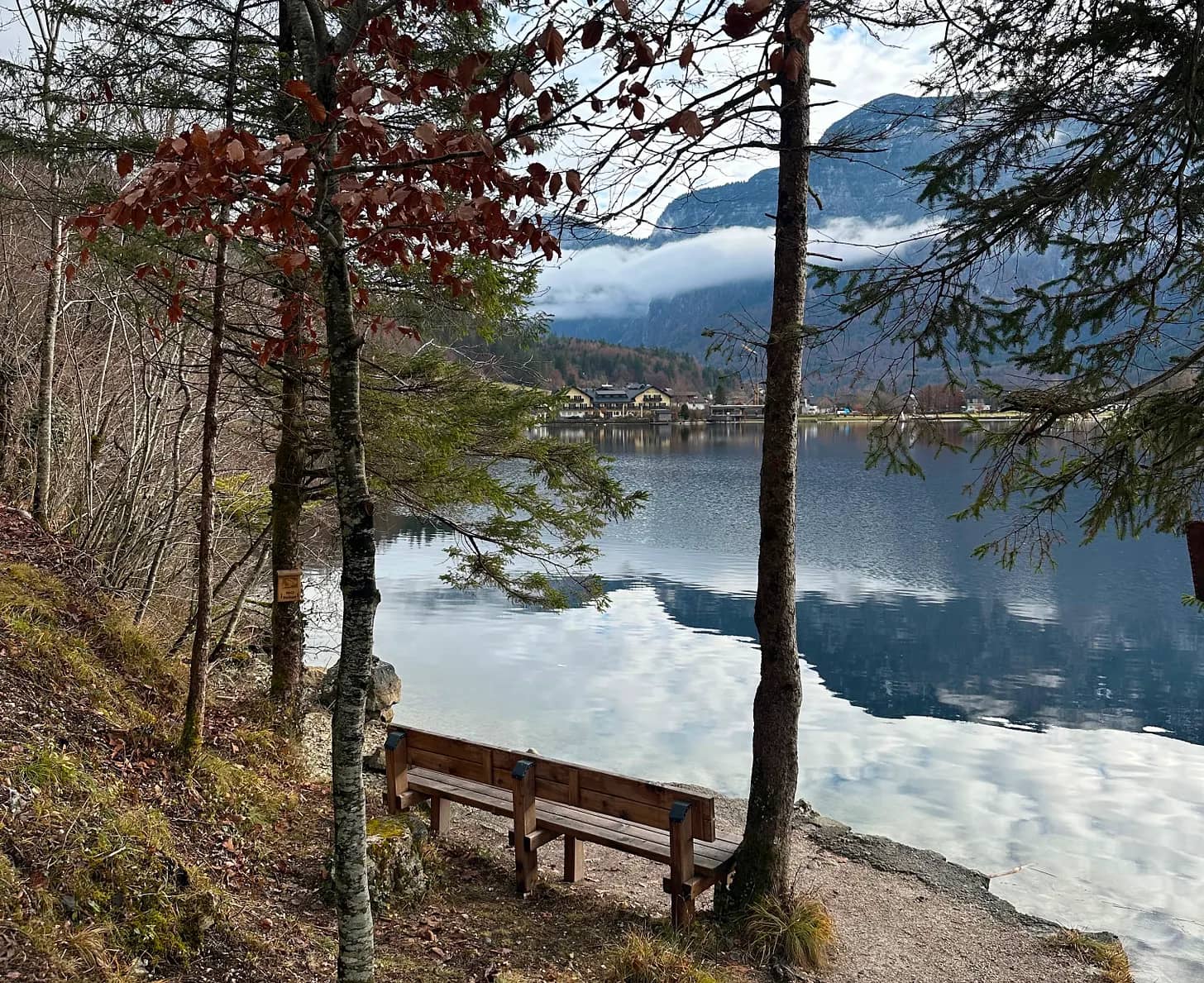
With the help of Google and AI, I optimised the perfect route from Salzburg. Hallstatt sits across a lake from its own train station, and you can reach it by road, driving straight in, or by a combination of transport. I chose the complicated one: a scenic bus skirting the great Wolfgangsee, a few stops on a local train and, finally, a short boat ride that crosses the Hallstätter See in a perfect straight line to arrive at the prettiest village in Austria, perhaps in all the Alps.
But the optimisation failed. As the crowd came off the train and began to pile up on the pier, I overheard, in someone else’s conversation, what was about to become my problem: only cash. And of course, I had none. With very little hope I waited for the boat to dock and asked about possible exceptions. The answer was a dry, simple no. I was stranded on the wrong side of the lake.
I looked along the left shore and spotted a path; according to the map, the next village was an hour away on foot. The alternative was to wait for another train, which would take just as long, or to turn back. It looked like a pleasant walk in the sun, so I set off along what seemed to be a bicycle path, rising and falling for a few kilometres beside the water.
When I reached Obertraun I found a village that was picturesque, but a ghost. From where the village began, with its little alpine houses and small uninhabited hotels, I walked another twenty minutes, starting to doubt a strategy that had brought me, on foot, to nowhere.
A few metres past the chapel stood the famous ATM. At the bus stop, a tidy timetable announced the next service in an hour. After a short, warm exchange with the woman at the tourism office, centred on the activities winter would soon bring with the snow, I went back out to wander until it was time. The absolute silence was broken by a bus returning children from school. While they got off and scattered, running to their houses, mine arrived.
Minutes later I was sitting with my nose against the glass to follow, up close, the route that climbed to the Krippenstein ski centre, on the Dachstein massif, and brought me, finally, to Hallstatt.
The first impression didn’t come from the village but from the number of people with suitcases, large and very large, moving in every direction. For me this was a day trip; it took me a while to understand what was happening. Since the detour had cost me more time than planned, I concentrated on getting lunch, though without much success: places were closed, or open but with no interest in having me. I managed, in the end, a soup opposite the Protestant church.
I walked the village end to end in far less time than the sunny path had taken me. I read the angry signs at the viewpoints: you may take the postcard photo, but in silence and without showing enthusiasm.
Of course. Hallstatt had lived through a boom, especially after the postcard materialised into a village replicated brick by brick by a mining company in Boluo, in Guangdong province.
The village exists because of salt. Its mine, one of the oldest in the world, was run by the Habsburgs from Vienna: hence the name of the region, Salzkammergut, the salt chest of the crown. Today it is an attraction with a slide. It was closed for renovation, like the giant balcony they built for taking photos over the See.
Until the late nineteenth century, Hallstatt could only be reached across the lake or along mountain paths. Now two roads arrive, one along each shore.
With no viewpoints available and the sun already dropping, I made a point of covering every street, the ones that climbed and had no shops, the ones far from the panoramic spots. Even so, the village ran out quickly.
I took the bus back to Obertraun. I wasn’t going to give the boat people the satisfaction.
After waiting in the silence of the station, I boarded the empty train. At the next stop, Hallstatt’s, everyone got on.
Do you have a town next door? One you reached by accident and liked better than the famous one. Leave its name in the comments: I’m collecting them for a future piece.
Originally published in The Detour on 14 July 2026.
Four Sicilian beaches, and the best one isn’t the famous one.
The most useful warnings before a trip don’t come from guidebooks — they come from people who make a living receiving travellers. I learnt this working with hosts at Airbnb. Before my first trip to Sicily, a mendocina with Sicilian roots warned me: “To travel through Sicily, plan your trip around the colour of the sea and the sand, depending on what you like.” These are four I tried.
Vendicari
When I do road trips, I like to look at the map for places to add as intermediate stops. That’s how Vendicari appeared, on the way down from Noto towards the coast. A nature reserve where there were once tonnare; today, occasional flamingos and travellers chasing the promise of Caribbean sand. To reach Calamosche you walk a slightly arid trail, watching birds along the way. I don’t know whether it was the heat, the sun, or the intensity of a Sicilian autumn that still feels like summer, but after walking forty minutes under the sun towards the famous turquoise, I liked it, but I didn’t find myself there.
Isola Bella
Taormina is one of Sicily’s jewels: its Greek theatre, its views that feel like a balcony over Etna, its elegant streets, and lately, the fame of White Lotus. Parking the car was a challenge I wouldn’t wish on anyone: streets with impossibly steep gradients, a tiny car park, and a crowd that overwhelms. It felt a little like stepping out of the Sicily I’d been living in. After wandering and walking up to the next village, I decided to visit Isola Bella. The cable car connecting the historic centre to the Mazzarò coast was closed — I think because of strong winds. Luckily, the heat at Calamosche had already trained me to walk in high temperatures, and going down is always easier than going up. The view is the beautiful postcard we all know. But I didn’t stay for the day: the shallow water, the jellyfish, the crowds. Obligatory photo, and I left. Not my cup of tea.
These days, the most photographed beach of a place and the best beach of a place are almost never the same.
Giardini Naxos
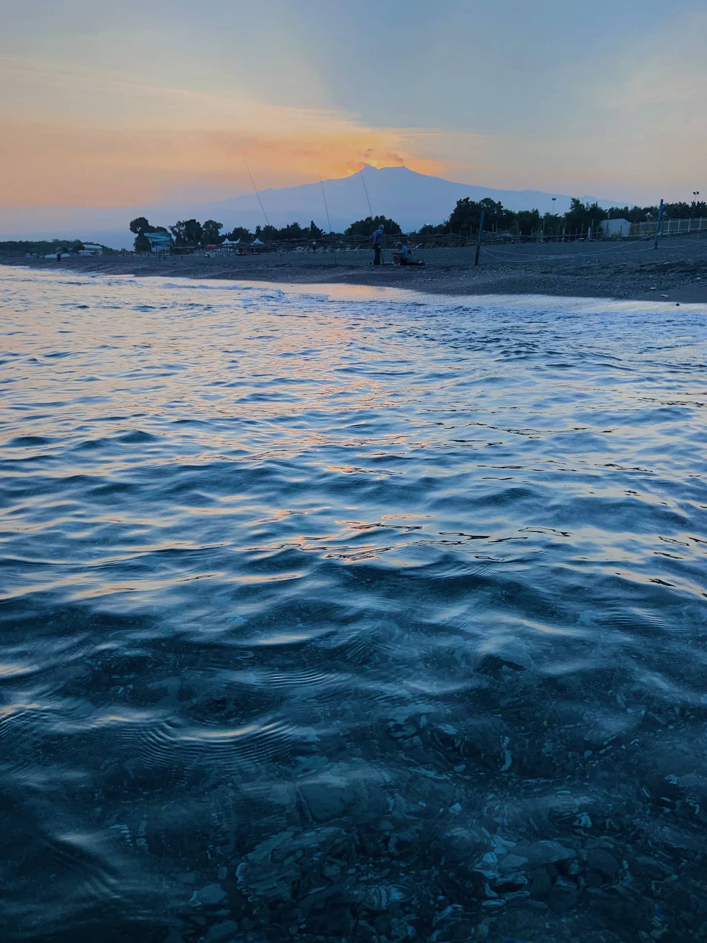
I rented the flat of the mendocina host, the same one from the warning, and let myself stay somewhere off the circuit, at the foot of Taormina. It isn’t a magazine destination. Walking towards the fishmonger waiting with i ricci, the signs spoke to me in Italian and in Cyrillic; the Russians discovered this stretch of coast decades ago, before fashion looked this way. I gained breakfasts and dinners listening to the waves. The beach is long, of black sand: the same sand you slide down running when you trek up Etna. Going out for a jog in the morning and slipping into the sea on the way back. A sea that drops off quickly, only a few steps before you can swim. Fish passing by, the water a deep blue — not the turquoise of postcards but something deeper, transparent all the same — and Etna erupting in the distance.
Etna erupts almost always, and watching it with its explosions while floating on a beach made of its own sand wasn’t a tourist curiosity, but learning what Sicilians have known for centuries: that you can live close.
Favignana
It isn’t quite Sicily. It’s an island apart, off the west coast, an hour by ferry from Trapani. And unlike the others, it isn’t a place to arrive at but to wander through: by bike or by golf cart, from one cove to another, jumping off the rocks into transparent water, going back the next day to the one you liked best. If you’ve travelled European beaches, you probably own a pair of water shoes; mine came from a stall at the port. A detour within the detour.
What would your beach be? The one at the end of the hot trail, the postcard one, the one by Etna, or the ones in Favignana by bike? It says more about you than about Sicily.
Originally published in The Detour on 27 May 2026.